“Transportation Planning" covers three main plans:
- The long-range Transportation System Plan, which is reviewed every 3-5 years and covers a 20-year timeline;
- The short-range Tribal Transportation Improvement Plan which covers a 5-year timeline of BIA-allocated Roads Program funds; and
- The Local Road Safety Plan, which covers a 5-year timeline and focuses on projects eligible for the Tribal Transportation Safety Program Fund.
Tribal Transportation Improvement Plan (3 to 5-year)
The Tribal Transportation Improvement Plan covers improvements that can be implemented by the CTUIR Roads Program under the Public Works Department within the next 3 to 5 years. This is a financially constrained plan and does not include projects which are anticipated to be funded by competitive grant requests. The plan includes maintenance funds of up to 25% of each year’s allocation; Roads program staff; planning and design for transportation projects; and small projects which are unlikely to be funded by a competitive grantmaking program. Planning and Public Works collaborate to update this plan approximately every 3-5 years.
Local Road Safety Plan (5-year)
The Local Road Safety Plan was first established in 2016 and is now undergoing revision and updates. This plan is established in order to make CTUIR eligible for the Tribal Transportation Program Safety Fund, a competitive grant program under the Tribal Transportation Program under the Federal Highway Administration (FHA). This can cover relatively small-scale transportation safety improvements which are supported by data, such as previous crash statistics, or road safety audits which analyze potential hazards in areas where crashes have not yet occurred. Because of the grant funds this plan is used for, this plan is required to set a target date for “Goal Zero” – the year we hope to improve the road system enough to have zero fatalities and serious injuries on roads across the entire Umatilla Indian Reservation. This date is aspirational, and provides a goal for Planning, Public Works, Tribal Police, and other agencies operating on the reservation to strive for.
CTUIR’s transportation safety planning is primarily dependent on crash data provided by ODOT, which includes crashes reported by all police departments that respond to crashes on the Umatilla Indian Reservation – Umatilla Tribal Police Department, Umatilla County Police, and State Troopers.
Interested in providing input to this ongoing plan update? Please visit the survey linked below:
The CTUIR Transportation System Plan was 21 years old, and due for an update. In 2021, CTUIR was awarded a grant from the State of Oregon to conduct the research, community engagement, and plan writing to develop the next 20-year plan for CTUIR’s Transportation System Plan. That process just wrapped up! Over the past year, we reviewed past CTUIR plans, conducted new traffic studies, and reached out to the community for input on how everyone gets around, and wants to get around the Umatilla Indian Reservation.
Transportation System Plan (20-year)
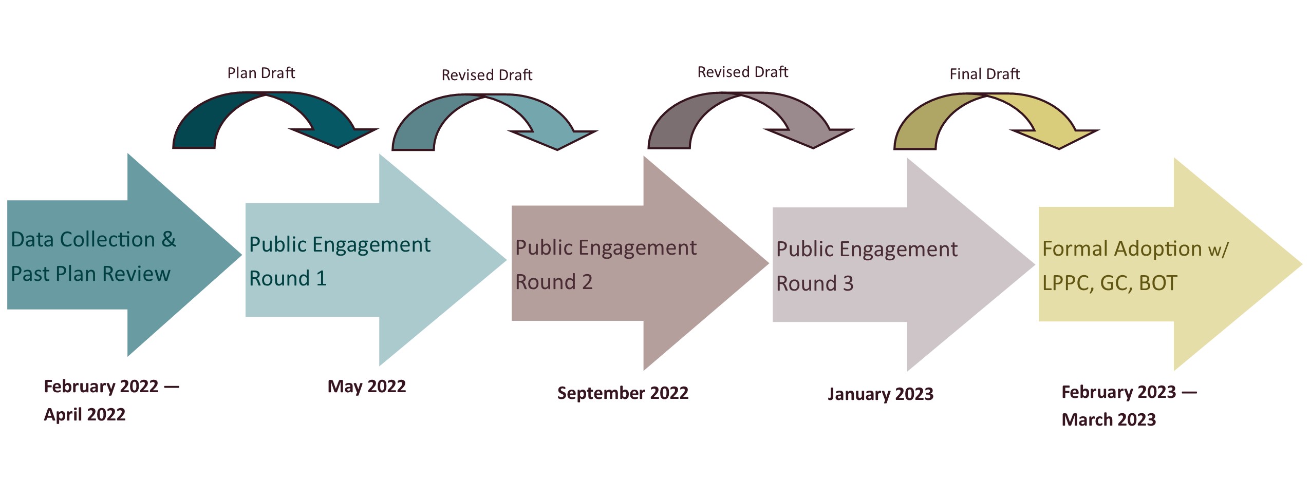
The CTUIR Transportation System Plan was updated over 2022 and 2023 with extensive traffic studies, research and reporting on past plan progress, and technical and community input. We conducted 3 rounds of public engagement in spring, summer and fall, and wrapped up with plan review and approval by the Land Protection & Planning Commission, CTUIR General Council, and the Board of Trustees. The plan was adopted in April of 2023, by the Board of Trustees, and is now in the implementation phase with policy revisions, advocacy, and construction of proposed projects ongoing.

So much has changed on the Umatilla Indian Reservation in the past 20 years. In 2001:
- Kayak was merely being planned, and was established later that year.
- The Wy-it View subdivision was being contemplated, and the road network was expected to grow in that area to serve it.
- The bike lanes on Mission road were established as a goal in the 2001 plan.
- A separated pedestrian bridge was envisioned to cross the Umatilla River near the Mission grain silos.
- CTUIR hoped to see a trail from Mission to Pendleton – a goal that has come up a number of times since then, but has not yet become a reality.
- Three bridges crossing the Umatilla River were in need of extensive repair and reconstruction. Two of those bridges were replaced, and the third is now underway.
A lot of that vision has become a reality; some was never developed; and some has yet to be developed still. The Transportation System Plan Update gives the CTUIR community a chance to weigh in on what they hope to see from the next 20 years development of roads, sidewalks, bike lanes, and trails.
The Partners
The 2023 amendment to the CTUIR Transportation System Plan is complete, however the Tribal Planning Office will review the plan annually, and make amendments approximately every 5 years. We encourage you to continue providing feedback about the CTUIR Transportation System, as we will compile this feedback during the 5-year review process in order to incorporate changes desired by the community. The next update of the Transportation System Plan is scheduled to begin in 2026.
Project Team
This group shepherded the process of the plan update, including researching past plans, conducting traffic studies, facilitating public engagement, and drafting documents.
- CTUIR Planning Office
- CTUIR Public Works Department
- ODOT Region 5
- Kittelson & Associates
- Angelo Planning Group
- Anderson Perry & Associates, Inc.
- SERA Architects, Inc.
Technical Advisory Committee
This committee reviewed drafts of plan chapters and discusses feasibility, identifies gaps, and finds opportunities for cooperation on target projects.
- CTUIR Public Works Department
- CTUIR Department of Economic & Community Development
- Kayak Public Transit
- Yellowhawk Public Health Center
- ODOT Region 5
- Umatilla County
- U.S. Forest Service
- Wildhorse Resort & Casino
The Community
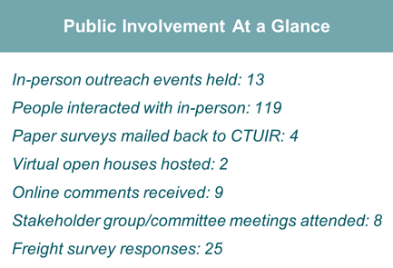
Thank you to everyone who weigh in on transportation improvements they wanted to see like to see over the next 20 years! Opportunities included:
- The below webmap
- Feedback by phone (contact information below)
Past Outreach events:
- February 14, 2023: Capital Improvements Committee
- February 14, 2023: Fish & Wildlife Commission
- February 16, 2023: CTUIR General Council
- February 21, 2023: Health Commission
- February 21, 2023: Law & Order Commission
- March 3, 2023: Elders Committee
- March 5, 2023: Tribal Youth Council
- March 14, 2023: Land Protection & Planning Commission – Public Hearing
Round 1 Outreach events (past):
- May 18, 2022: Senior Center Lunch
- May 18, 2022: Mission Market (afternoon)
- May 19, 2022: Mission Market (noon hour)
- May 19, 2022: NGC rotunda
- May 19, 2022: Yellowhawk lobby
- May 22, 2022: Tribal Youth Council meeting
- June 9, 2022: Longhouse (Treaty Day)
Round 2 Outreach events (past):
- September 21, 2022: Mission Market (afternoon)
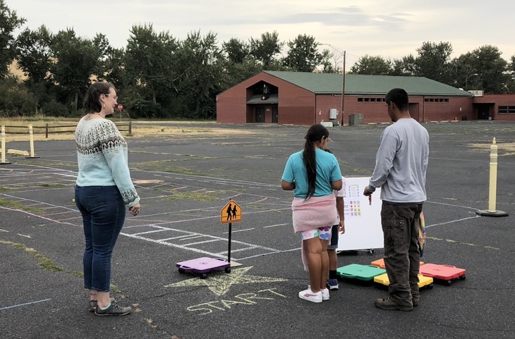
- September 21, 2022: After School Program Traffic Garden
- September 22, 2022: Mission Market (noon hour)
- October 4, 2022: Law & Order Commission
- October 11, 2022: Fish & Wildlife Commission
- October 11, 2022: Capital Improvements Committee
- October 11, 2022: Health Commission (virtual engagement)
- October 20, 2022: NGC Rotunda
- November 18, 2022: Senior Center Lunch
- January 10, 2023: Arrowhead Travel Plaza Freight Survey

The Plan
Summary
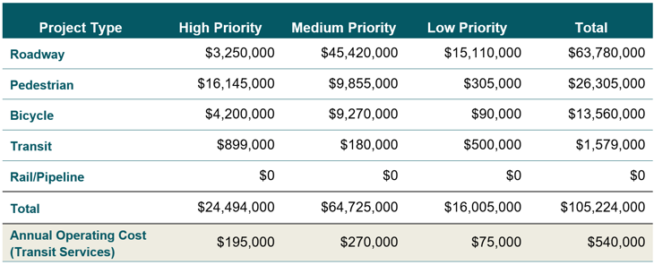
The updated Transportation System Plan reflected a change in community priorities regarding how they get around the community, and how they would like to do so. In contrast with the 2001 plan, many community members expressed a desire for walking, bicycling, and horseback riding routes that are safer than the shoulder of the high speed rural roads currently available for those uses, and the updated project list reflects those wishes. The new plan includes 23 pedestrian and off-road trail improvements, and 11 new bicycle route improvements.

The projects were identified by reviewing past plans, asking community members what they wanted to see, and consulting transportation professionals about imminent or planned projects. This list was then prioritized based on metrics related to the seven goals identified early in the planning process: 1. Safety; 2. Environment & Cultural Heritage; 3. Health; 4. Equity & Accessibility; 5. Connectivity; 6. Coordination; and 7. Financial Stability. During the engagement process, community input was used to move projects up or down in priority based on positive or negative community feedback to result in the final project ranking. High priority projects will be pursued most quickly by CTUIR, either by allocating available funds or by seeking competitive grant funds.

The design team did a focused location plan at two sites on the reservation – Mission Road and Highway 331 near Wildhorse Resort & Casino. These areas were identified as areas where a lot of transportation improvements are needed to suit the needs of the growing UIR community, as the main transportation corridor of the community and tribal services in the case of Mission, and as the main commercial center of the reservation in the case of Highway 331 near Wildhorse. While the Mission Road improvements were identified as high priority to improve road, pedestrian and bicycle safety, the Wildhorse commercial area transportation improvements are considered “development-driven”, meaning when new businesses are established nearby, these improvements may become necessary, but are not needed at the current level of development. A copy of the complete draft plan can be found in the “files” section at the bottom of this page. To share feedback on the plan, please contact Dani Schulte, Transportation Planner for CTUIR.
On April 24, 2023, the CTUIR Board of Trustees adopted the Transportation System Plan, with unanimous approval.
The Future
The Transportation System Plan, adopted April 24th, 2023, is just one step towards making transportation improvements on the Umatilla Indian Reservation a reality. The Tribal Planning Office is required to review this plan annually, and update the plan every 5 years. The next plan update will begin in 2027. Working toward the goal of implementing this plan will take action by many community stakeholders, and we hope to build relationships to get this work done using every tool available.
Tribal Transportation Improvement Plan (TTIP)
This plan is the 3-5 year plan for the use of Formula Funds allocated to the CTUIR Roads Program for annual operations and maintenance of roads which are on the Road Inventory – these are all BIA and CTUIR-owned roads, as well as other local roads which are critical to the Reservation community. The TTIP funding can only cover the cost of 1 or 2 small construction projects each year, so the Roads Program relies on competitive grants and partnerships with local public agencies and businesses to build out the new projects desired by the community.
Competitive Grants
CTUIR applies for many competitive grants from the BIA, the Federal Highway Administration, the State of Oregon, and private and non-profit entities to build new projects. Some of our successful grant applications include:
- Oregon Transportation Growth Management: this grant award funded the overhaul of the CTUIR Transportation System Plan in 2021-2023. The TGM program also funded an update to the Mission Community Plan in 2017.
- ODOT Safe Routes to School: this grant award funded a trail from Mission Market to Timine Way along the west side of Highway 331, to be completed in 2023-2024.
- ODOT Community Paths: this grant award funded a spur trail that will connect the future Highway 331 trail to the Timine Way trail, north of the Nixyaawii Governance Center.
- FHWA Tribal Road Safety Program: this grant award funded an update to the CTUIR Local Road Safety Plan, which is scheduled to be completed in 2023.
Partnerships
The Tribal Planning Office is always seeking ways to find mutually beneficial agreements with other road jurisdictions, other CTUIR departments, and local agencies or businesses to achieve our transportation goals. Some of these are formalized policies that will be carried out through the implementation of the updated TSP, such as the development of a bus stop sponsorship policy that we hope will entice local businesses to sponsor nearby bus shelters to serve their employees as well as the greater community. These community partnerships are critical to achieving shared goals, and we hope they will expand the available resources to make transportation on the Umatilla Indian Reservation safer, healthier, and more accessible to all.
Other Funding Opportunities
The Tribal Planning Office will seek out other opportunities as they arise. Sometimes funds become available through the Statewide Transportation Improvement Program (STIP) which are sought as more of a lobbying effort to ensure that the CTUIR community’s transportation goals are well represented on Oregon’s infrastructure priority system. Sometimes these come in the form of political lobbying efforts to apply earmarked transportation funds to CTUIR priorities. We will continue to seek creative opportunities to make the TSP a reality.
Would you like to share input about the CTUIR Transportation System? Please call our Transportation Planner, Dani Schulte, at 541-429-7525.
To review past feedback we received, view the map below to see projects where we collected public comments to inform the Plan.
Want to see input from the May 2022 round of community engagement? View the prior comment map here!
The way forward is up to you!


